According to the guide book and map we estimated these distances for each day:
Day 1 – Louie Lagoon to Third Beach: 1 km
Day 2 – Third Beach to Calvin Falls: 11.5 km
Day 3 – Calvin Falls to Beano Creek: 10.5 km
Day 4 – rest day at Beano Creek: 0 km
Day 5 – Beano Creek to sea caves: 10.5 km
Day 6 – Sea caves to Yuquot: 4 km
Total: 37.5 km not including beach exploration :-)
Here's a map showing Nootka Island and the main waypoints of the trip.
Did it feel like only 37.5 km? After all, we've hiked further, with more elevation gain in less time both before and since that trip. I think the answer is yes it did and no it didn't feel like only 37.5 km. Yes, because we spent a sizeable fraction of each travel day just relaxing and doing nothing. No, because there were stretches where it was very slow going.
Things that made the hike difficult:
1) frequent hauling body over/under trees and/or up/down steep slopes
2) super-slippery rocks
3) pea gravel
4) hiking in hot sun
The elevation gain is zero, of course – it's a coastal hike. But there are stretches where you expend a lot of energy getting you and your 50-lb pack across many obstacles. As a result, you don't get much chance to get into a rhythm and I found I tired much more quickly than I would otherwise have done.
I would say for anyone doing this hike to do what it takes to keep cool when hiking out on the beach. Hiking from north to south left us facing the sun at all times and the thick undergrowth made it impossible to nip into the trees for a bit of shade. Of course, that assumes you see the sun – it is entirely possible that the sun might not make its presence felt!
We were very, very lucky with the weather. We planned the dates to get the right tides. But we could not have predicted the dry summer which made all our creek crossings easy or even non-existent. We also had good weather for the duration of our trip. I'm sure that a bit of rain would have made things feel very different.
Even with our good fortune there were times I could have sat down and not gone any further. But when you're out in the middle of nowhere with three others and no way to get to your destination other than your own two feet, you don't really have much choice :-) You have to keep going, so plenty of stamina and a healthy dose of bloody-mindedness works wonders!
So why is it that this hike, above all the other back-packing trips of summer 2006, keeps drifting back into my mind? I think it was the remoteness, the peace and quiet and the company of three great companions (of course I am married to one of them :-) It really helped that we all had the same outlook on the hike too so there were no egos pulling in different directions.
The key test of a hike is, would I do it again? The answer is unreservedly Yes.
Wednesday, March 07, 2007
Sunday, February 25, 2007
Day 6: Sea caves to Yuquot and home
We awoke at dawn. At least, that's what the alarm clock said. Inside the cave, it was still quite dark. A really good night's sleep too! Even though the sea was quite loud in the cave, it provided a soothing white-noise background which made it easy to sleep. And not worry about little scurrying sounds from the local wildlife! Even Merewyn telling us of the scary experience of some friends from the previous year couldn't keep me awake. (Apparently they heard some weird noises around 4am and couldn't get back to sleep... Creepy!)
After the usual ITF visit and retrieving the food bags, it was time to have our last breakfast on the Nootka Trail. The rain had stopped and we had another clear blue sky to greet us. We ate breakfast around the remains of last night's camp fire, and then set about packing up for the last time.
We were in no great hurry this morning (though we did have to be at the tidal lagoon at low tide) yet we were ready to leave by 8.30 am. One last look around, and it was farewell to the caves. I think we had mixed feelings about that camp spot. It did have a different feel from the others, probably due to its enclosed nature and it was our last night. So although we were sorry to leave it all behind, it felt good to be moving.
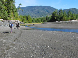
We only had 4 km to hike to make the ferry by 2pm. Easy, especially with noticeably lighter packs (finally!). For the next hour we encountered more beaches than we could count: scrambling up, down and over. Before long we caught our first glimpse of Yuquot (Friendly Cove), but that didn't mean we had it easy. Oh no. I think we climbed up from and down onto more little beaches in that couple of km to the tidal lagoon than on any other portion of the trail.
And then we were there – Tsa'tsil, the place where the tide comes in and out. And the tide was out, leaving us only a shallow stream to cross. Like the stream at Calvin Falls, it was deceptively fast running and it took a little while to find the right place to cross. Maria just took off her boots and donned her sandals (of course, Brenda didn't need to worry about it) but as usual I was too lazy to do that.
On the other side, we paused for a minute or two and then my memory fails me but I know we all turned our back on Merewyn to offer her privacy for some reason. Of course, over the last few days that was all that was necessary with no one else around. She buttoned up just in time as suddenly two more hikers appeared over the edge of the sand dune! We chatted with them for a bit and it turned out that they were the pair that had set out 2 days before us. They had spent last night by the lagoon.
We said our good-byes and set off along the beach. It may have been only a mile or so but it felt like forever. It was hard going too. Not as bad as the pea gravel but it was still a soft surface that soaked up a lot of energy. We passed Mawinnis Rock, a sea stack which marks the boundary of Yuquot, and decided to head into the forest to follow the Yatz-mah trails. We followed some flagging into the trees but quickly lost all evidence of a trail and found ourselves in the middle of a forest with no clear path and an awful lot of salal (and cobwebs!) to plough through. We backtracked and tried again but ended up at exactly the same spot. We were hoping to make it through to the edge of Jewitt Lake for a pleasant resting point, but quickly gave up on that idea.
So we ended up following the wide path which led to the cabins. And then we came across this strange building. A small, narrow building with steps leading up to a single door of the same width. Upon opening the door we encountered a raised plastic pedestal with a hole in the top. Our first toilet in almost a week! Well, we couldn't say no and with some amusement made full use of the available facilities.
We did get to see Jewitt Lake by taking a trail down past one of the cabins, but it wasn't the most scenic of spots, being next to a water pump and filter assembly and an old rusty tank. We managed a nice picture of it though as it was like a mirror. Jewitt Lake is named for John Jewitt, the Englishman who was held captive for two years on Nootka. Its native name is Aa-aak-kwaksius Lake.
We continued along path into Yuquot, passing an old overgrown cemetary, a relic of the conversion to Christianity. We soon found ourselves in the middle of the village. We passed a sign advertising camping, and came to a large open field with a couple of tents in it. But these weren't just campers. In summer the Mowachaht-Muchalaht people return to Yuquot to spend time there, returning to their current homes for the winter. Yuquot only has a couple of year-round residents, along with the lighthouse keeper. We approached the church and met a fellow named Paul. He greeted us and after a few pleasantries asked about our receipt. Merewyn dug it out of her pack and he was satisfied. We asked about the church and he said that we were free to look around wherever we wanted, take photos and ask questions. He also told us that Sanford Williams, the master carver, was in today and we'd be able to visit his workshop and see what he was working on.
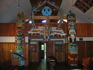
We thanked him and went into the church, dropping our packs at the entrance. The church is now a museum and we spent quite a while quietly reading about the history of Yuquot, of Captain Cook's first contact and other events. Two of the most striking features of the church/museum are the commemorative stained glass windows which celebrate the bicentennial of the signing of the Nootka convention which brought peace between Britain and Spain over that part of the west coast of North America. We signed the guest book. In the main part of the church we were greeted by some amazing totem poles and other carved art work, all decorated in bright cheery colours.
It was here that we ran out of space on our last memory card. Oh dear. We'd had to buy a new memory card for the camera mid-way through a camping trip in 2005 but we were car camping so it was easy to call in somewhere and get another one. Not here. So it was time to sift through the photos and delete the obviously bad ones!
Having cleared a little space, we wandered down towards the water and were stopped in our tracks by the extensive blackberry bushes. No, they weren't blocking our way – they were festooned with big ripe blackberries! For the next 15 minutes we did nothing but gorge on fresh fruit. A real luxury after nearly a week of dried food! As we walked along the pathways through the bushes garter snakes darted here and there. At one point we came across the obligatory pile of bear poo, clearly indicating it too had eaten a lot of blackberries.
Once we were verging on nausea from overindulging on ripe fruit, we went over to the carver's workshop. He was working on a mask, and was happy to talk about his work. We had a look around at the several pieces on display, some almost finished, some barely started. The one that caught my eye was a bentwood box – I think these are amazing. We asked about the totem pole in preparation down by the water and he told us it was for a hotel in Tofino. A new yellow cedar pole, probably 20 feet long (and not cheap at $5000 per foot!), complete with pencil outlines. I'd like to see it when it finished (apparently by the end of 2007).
We thanked him and wandered off to find the fallen totem pole that we had read about. It was almost overgrown with blackberry bushes. Apparently the tradition is that it has to lie there until it rots, so it will not be set upright anywhere, nor sold to a museum. We spent a little while looking over it and taking some photos. It was an impressive pole with lots of interesting carvings on it.
From there we walked over to the lighthouse to take a look around. There was another guest book here, and a small mirror so it was possible to view myself for the first time in days. Everyone took turns to look at their own reflection and we all went "Ewww! Do I really look like that?" :-) I hadn't shaved in almost a week, something I had not done for, err, 20 years...!
We chatted with the lighthouse keepers for a while and they told us about life as a lighthouse keeper at Yuquot. When the weather's fine, it sounded like a pleasant, mostly peaceful existence. But in the winter, they're basically on their own to face the winter storms. That might be fun for a short time, but I think the novelty would wear off pretty quickly! Unfortunately we couldn't go up in the lighthouse itself because of the asbestos in there. It's not a big lighthouse, but it is one of the few that has keepers stationed all year round.
While at the lighthouse, our ferry appeared (on time at 12:30): the MV Uchuck III, a converted minesweeper. What looked like a small army of day-trippers disembarked and streamed into the village. Then the Uchuck disappeared. Literally. One minute it was at the dock, the next it had gone! I think my perception of time must have changed during the course of the trip. We drifted about for the next hour or so and made our way out onto the dock. 2pm came and went and there was no sign of the Uchuck! And then just as mysteriously, it reappeared chugging its way to the dock.
We made our way on board with the rest of the crowd (and it really felt like a crowd), dropped our packs in a safe place out of the way and headed down into the galley for lunch! One of the features of the Nootka Trail is that lunch is provided on the last day courtesy of the Uchuck, and the chilli is legendary. Now I was expecting that earning the "legendary" title had more to do with starving hikers willing to eat anything but I was wrong. It was actually pretty good chilli and between us we disposed of four bowls of the stuff. And a muffin each.
And so we bid farewell to Yuquot, Nootka Island and the Nootka Trail. We spent the journey back to Gold River watching the scenery go by (some very scenic logging cut-blocks – not), taking a few last minute photos of each other and finally just soaking up some (more) sunshine. It looked like a great area to do some kayaking, and it is popular with kayakers so maybe sometime in the future (once I've sorted out my frozen shoulder)...
We eventually steamed into Gold River, and made our way off the ferry. We dropped off our packs at Brenda's car, collected our change of clothes and went over to the Air Nootka office to say "Hello" (and borrow their bathroom to change in). Suddenly, back in civilization we need the protection of a locked door to change clothes! It was nice to drop in and fill them in on our week – nice folks running that place. I wonder how they got on with their first full winter there.
And before we knew it, we were back in the car and heading back to Nanaimo for the ferry. With Super Dog leading the way, and a mix of Neil Diamond and John Denver (not my choice, honest) to soothe our ears we sped off down the Island. We missed our ferry by a few minutes, which meant only one thing: time for a burger and a beer at the pub!
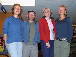
We made it onto the 9.15pm ferry, feeling tired and wondering why we weren't heading for bed. :-) It seemed so busy, so crowded. A real shock to the system. We found a quiet corner where the four of us could sit and we wiled away the hour and a half crossing. Time for one or two last group photos though! Four cheery hikers. Six spectacular days.
We were home by midnight and just dropped our packs out on the balcony. A luxurious hot shower, and a soft clean bed awaited. It was over. We were home.
After the usual ITF visit and retrieving the food bags, it was time to have our last breakfast on the Nootka Trail. The rain had stopped and we had another clear blue sky to greet us. We ate breakfast around the remains of last night's camp fire, and then set about packing up for the last time.
We were in no great hurry this morning (though we did have to be at the tidal lagoon at low tide) yet we were ready to leave by 8.30 am. One last look around, and it was farewell to the caves. I think we had mixed feelings about that camp spot. It did have a different feel from the others, probably due to its enclosed nature and it was our last night. So although we were sorry to leave it all behind, it felt good to be moving.
We only had 4 km to hike to make the ferry by 2pm. Easy, especially with noticeably lighter packs (finally!). For the next hour we encountered more beaches than we could count: scrambling up, down and over. Before long we caught our first glimpse of Yuquot (Friendly Cove), but that didn't mean we had it easy. Oh no. I think we climbed up from and down onto more little beaches in that couple of km to the tidal lagoon than on any other portion of the trail.
And then we were there – Tsa'tsil, the place where the tide comes in and out. And the tide was out, leaving us only a shallow stream to cross. Like the stream at Calvin Falls, it was deceptively fast running and it took a little while to find the right place to cross. Maria just took off her boots and donned her sandals (of course, Brenda didn't need to worry about it) but as usual I was too lazy to do that.
On the other side, we paused for a minute or two and then my memory fails me but I know we all turned our back on Merewyn to offer her privacy for some reason. Of course, over the last few days that was all that was necessary with no one else around. She buttoned up just in time as suddenly two more hikers appeared over the edge of the sand dune! We chatted with them for a bit and it turned out that they were the pair that had set out 2 days before us. They had spent last night by the lagoon.
We said our good-byes and set off along the beach. It may have been only a mile or so but it felt like forever. It was hard going too. Not as bad as the pea gravel but it was still a soft surface that soaked up a lot of energy. We passed Mawinnis Rock, a sea stack which marks the boundary of Yuquot, and decided to head into the forest to follow the Yatz-mah trails. We followed some flagging into the trees but quickly lost all evidence of a trail and found ourselves in the middle of a forest with no clear path and an awful lot of salal (and cobwebs!) to plough through. We backtracked and tried again but ended up at exactly the same spot. We were hoping to make it through to the edge of Jewitt Lake for a pleasant resting point, but quickly gave up on that idea.
So we ended up following the wide path which led to the cabins. And then we came across this strange building. A small, narrow building with steps leading up to a single door of the same width. Upon opening the door we encountered a raised plastic pedestal with a hole in the top. Our first toilet in almost a week! Well, we couldn't say no and with some amusement made full use of the available facilities.
We did get to see Jewitt Lake by taking a trail down past one of the cabins, but it wasn't the most scenic of spots, being next to a water pump and filter assembly and an old rusty tank. We managed a nice picture of it though as it was like a mirror. Jewitt Lake is named for John Jewitt, the Englishman who was held captive for two years on Nootka. Its native name is Aa-aak-kwaksius Lake.
We continued along path into Yuquot, passing an old overgrown cemetary, a relic of the conversion to Christianity. We soon found ourselves in the middle of the village. We passed a sign advertising camping, and came to a large open field with a couple of tents in it. But these weren't just campers. In summer the Mowachaht-Muchalaht people return to Yuquot to spend time there, returning to their current homes for the winter. Yuquot only has a couple of year-round residents, along with the lighthouse keeper. We approached the church and met a fellow named Paul. He greeted us and after a few pleasantries asked about our receipt. Merewyn dug it out of her pack and he was satisfied. We asked about the church and he said that we were free to look around wherever we wanted, take photos and ask questions. He also told us that Sanford Williams, the master carver, was in today and we'd be able to visit his workshop and see what he was working on.
We thanked him and went into the church, dropping our packs at the entrance. The church is now a museum and we spent quite a while quietly reading about the history of Yuquot, of Captain Cook's first contact and other events. Two of the most striking features of the church/museum are the commemorative stained glass windows which celebrate the bicentennial of the signing of the Nootka convention which brought peace between Britain and Spain over that part of the west coast of North America. We signed the guest book. In the main part of the church we were greeted by some amazing totem poles and other carved art work, all decorated in bright cheery colours.
It was here that we ran out of space on our last memory card. Oh dear. We'd had to buy a new memory card for the camera mid-way through a camping trip in 2005 but we were car camping so it was easy to call in somewhere and get another one. Not here. So it was time to sift through the photos and delete the obviously bad ones!
Having cleared a little space, we wandered down towards the water and were stopped in our tracks by the extensive blackberry bushes. No, they weren't blocking our way – they were festooned with big ripe blackberries! For the next 15 minutes we did nothing but gorge on fresh fruit. A real luxury after nearly a week of dried food! As we walked along the pathways through the bushes garter snakes darted here and there. At one point we came across the obligatory pile of bear poo, clearly indicating it too had eaten a lot of blackberries.
Once we were verging on nausea from overindulging on ripe fruit, we went over to the carver's workshop. He was working on a mask, and was happy to talk about his work. We had a look around at the several pieces on display, some almost finished, some barely started. The one that caught my eye was a bentwood box – I think these are amazing. We asked about the totem pole in preparation down by the water and he told us it was for a hotel in Tofino. A new yellow cedar pole, probably 20 feet long (and not cheap at $5000 per foot!), complete with pencil outlines. I'd like to see it when it finished (apparently by the end of 2007).
We thanked him and wandered off to find the fallen totem pole that we had read about. It was almost overgrown with blackberry bushes. Apparently the tradition is that it has to lie there until it rots, so it will not be set upright anywhere, nor sold to a museum. We spent a little while looking over it and taking some photos. It was an impressive pole with lots of interesting carvings on it.
From there we walked over to the lighthouse to take a look around. There was another guest book here, and a small mirror so it was possible to view myself for the first time in days. Everyone took turns to look at their own reflection and we all went "Ewww! Do I really look like that?" :-) I hadn't shaved in almost a week, something I had not done for, err, 20 years...!
We chatted with the lighthouse keepers for a while and they told us about life as a lighthouse keeper at Yuquot. When the weather's fine, it sounded like a pleasant, mostly peaceful existence. But in the winter, they're basically on their own to face the winter storms. That might be fun for a short time, but I think the novelty would wear off pretty quickly! Unfortunately we couldn't go up in the lighthouse itself because of the asbestos in there. It's not a big lighthouse, but it is one of the few that has keepers stationed all year round.
While at the lighthouse, our ferry appeared (on time at 12:30): the MV Uchuck III, a converted minesweeper. What looked like a small army of day-trippers disembarked and streamed into the village. Then the Uchuck disappeared. Literally. One minute it was at the dock, the next it had gone! I think my perception of time must have changed during the course of the trip. We drifted about for the next hour or so and made our way out onto the dock. 2pm came and went and there was no sign of the Uchuck! And then just as mysteriously, it reappeared chugging its way to the dock.
We made our way on board with the rest of the crowd (and it really felt like a crowd), dropped our packs in a safe place out of the way and headed down into the galley for lunch! One of the features of the Nootka Trail is that lunch is provided on the last day courtesy of the Uchuck, and the chilli is legendary. Now I was expecting that earning the "legendary" title had more to do with starving hikers willing to eat anything but I was wrong. It was actually pretty good chilli and between us we disposed of four bowls of the stuff. And a muffin each.
And so we bid farewell to Yuquot, Nootka Island and the Nootka Trail. We spent the journey back to Gold River watching the scenery go by (some very scenic logging cut-blocks – not), taking a few last minute photos of each other and finally just soaking up some (more) sunshine. It looked like a great area to do some kayaking, and it is popular with kayakers so maybe sometime in the future (once I've sorted out my frozen shoulder)...
We eventually steamed into Gold River, and made our way off the ferry. We dropped off our packs at Brenda's car, collected our change of clothes and went over to the Air Nootka office to say "Hello" (and borrow their bathroom to change in). Suddenly, back in civilization we need the protection of a locked door to change clothes! It was nice to drop in and fill them in on our week – nice folks running that place. I wonder how they got on with their first full winter there.
And before we knew it, we were back in the car and heading back to Nanaimo for the ferry. With Super Dog leading the way, and a mix of Neil Diamond and John Denver (not my choice, honest) to soothe our ears we sped off down the Island. We missed our ferry by a few minutes, which meant only one thing: time for a burger and a beer at the pub!
We made it onto the 9.15pm ferry, feeling tired and wondering why we weren't heading for bed. :-) It seemed so busy, so crowded. A real shock to the system. We found a quiet corner where the four of us could sit and we wiled away the hour and a half crossing. Time for one or two last group photos though! Four cheery hikers. Six spectacular days.
We were home by midnight and just dropped our packs out on the balcony. A luxurious hot shower, and a soft clean bed awaited. It was over. We were home.
Friday, February 23, 2007
Day 5: Beano Creek to the sea caves
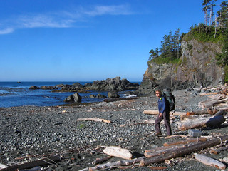
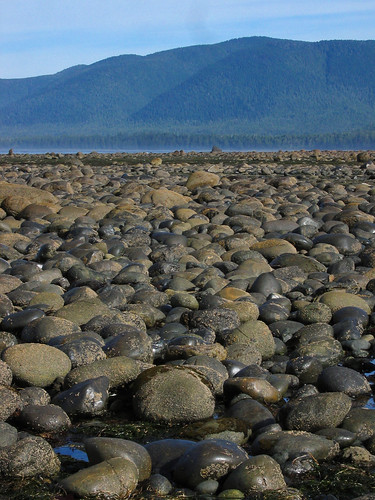
All good things must come to an end I suppose and we were back to our early starts. Another beautiful calm and clear morning greeted us as we sat around the remains of last night's camp fire eating breakfast. We hit the pebbles around 8am again, walking past the cabins, the wilderness retreat and a fish head impaled on a stick, courtesy of the jet-skiers. Within 20 minutes we had a novel experience: we were walking on solid ground! The tide was low so we walked under the cliffs, admiring the patterns in the wave-beaten rocks.
The only downside to taking this route was the climb we had ahead of us. The beach dead-ended in a gulley and the only way out was up the 30-foot cliff. Fortunately a knotted rope was there to help us and again we were thankful for the dry weather since the cliff was pretty mossy. We looked at each other and Merewyn decided to go first. She psyched herself up and away she went. A minute later she was at the top and looking back down at us, yelling that it was easy! Brenda next, in her sandals and aqua socks. Again no problem. Maria decided climbing it with her pack on was asking for trouble and she went up pack-less and made it easily (she had a huge grin of relief when she made it to the top). Then I tied her pack to the rope and it was hauled up. Now my turn. I contemplated free climbing since it was dry but decided that it wasn't worth risking the tumble back down. So I also used the rope, stopping half way up to take a photo of the faces peering down at me :-) It was not as bad as I expected but I must admit, tackling it in the wet would be a different story.
We emerged onto the top of the cliffs in obvious second-growth forest: lots of small skinny trees close together with little ground cover between them. Very unlike the dense forest that much of the trail is hacked out of. We were treated to occasional cliff-top views of calm, blue ocean (no whales though). After a short distance we descended into the real forest again, clambering over and ducking under fallen trees, passing by giant cedars. Before long we emerged on another beach, walking along until we reached Callicum Creek. Here we re-filled our water bottles since it would be the last water for a while (potentially for the rest of the trip).
Then we were back into the forest, then out onto a pocket beach, then back into the forest, etc. One of these gorgeous pocket beaches became our snack spot. Every morning after about an hour's walking, we all needed to stock up on the calories. This was a particularly nice beach, complete with a small shelter made by previous hikers. Now we had a good stretch of beach walking but it was easy going. Firm pebbles and gravel, occasional sand, some logs here and there. All the while hiking in the cool shade of the trees, admiring the westerly ocean view. Beautiful hiking conditions.
Getting up off (or down onto) the pocket beaches usually required scrambling up a small incline with the help of rope, rocks, tree roots etc. Yes, it's a flat hike overall but there are plenty of short climbs to ensure a full body workout! The trail markers were invariably fishing floats tied to the trees, occasionally adorned with such things as dead starfish.
Eventually we ran out of exciting climbs and we were up on the cliffs. It was cooler and breezier up here, clearly shown by the numerous twisted trees surrounding us. We passed many pocket beaches but with no way down. At several points the trail was right on the cliff edge, and within a few years I expect the trail will need to be re-routed through the trees again. As we got closer to Maquinna Point the rocks became very interesting. They were lava-like with very sharp edges. Not a place to fall over. In many places the surface of the rock was eroded away, leaving undercut miniature plateaux.
We passed through a gap between the cliffs and a headland which needed a combination of a rope and a chain to edge through so we wouldn't fall into the murky-looking pool below. Very Lord of the Rings :-) Then we came to another beach, and another scramble at the end to return to the forest. By now it was nearly lunchtime and we reached the turnoff to a small lake which could be used for fresh water. We ummed and ahhed for a bit, but decided to keep going, feeling that we had enough to last us. We pushed on to Maquinna Point with the aim of having lunch overlooking the sea.
Except when we got there it was so cold and windy that we stopped long enough to munch a quick snack and take a photo or two before heading back into the shelter of the trees. I was surprised by Maquinna Point: the cliffs were not as high as I expected. I guess I was thinking of the massive sea cliffs in the Orkneys when I read the descriptions but these were barely cliffs at all. Just offshore were a number of fishing boats – apparently the salmon fishing is good there.
So we headed back into the forest and decided to push on to the sea caves for lunch which were only another kilometre or so ahead of us. At one point we passed through a small swamp which at first seemed unremarkable but then we came to a patch festooned with gorgeous blue King Gentian flowers which stopped me in my tracks. Out came the camera :-) I think the others were a little hungrier than me as they had gone by the time I looked up! I spotted some sundew in amongst the swampy grass but couldn't get a good angle to take a photo.
Where were these sea caves? We were getting hungry and had taken a few wrong turns. If there's something I can pass on to future hikers it's pay attention to the trail markers! If they run out, you've taken the wrong trail! Just back up to the last marker and look for the next one. It works. It really works.
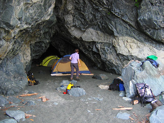
Before too long we descended again and stepped our way over fallen logs out onto a pebbly pocket beach. We had reached the sea caves! The setting was picturesque: small sea stacks and 30-foot cliffs enclosed a couple of pocket beaches. We found the entrance to the first cave and dropped our packs, pulling out the tent fly sheets to dry in the afternoon air. Time for lunch!
After lunch we explored the beach and found there were three caves. The main one we had first seen, a second smaller one at the top of the beach and a larger completely open cave. We considered that one since it was open at both ends but it was kinda draughty. The little one was too small so we decided on the centre cave. Inside it sloped upwards to the back of the cave. The floor was cool damp sand, and had many mouse and at least one set of wolf prints.
The only problem with that cave was the fact that the floor was on quite a slope. We made good use of some of the driftwood to level off the floor, banking it up at the front and excavating at the back to create a nice flat platform to pitch the tents. Brenda and Merewyn didn't quite spend as long on it as we did, and they still had a little slope. Surely that wouldn't be a problem though? Well, in any case they drew straws to see who would be the "squisher" and who the "squishee" that night :-)
Then we had another fine afternoon to explore the beach, read some more and generally chill out. I think we were all aware that it was the last full day of the hike and everyone was a little self-absorbed. I was happy to be there, but I could feel the first pangs of sadness that it would soon be over. But it was no time to think about the end of the trip: we were in a beautiful spot and there was nothing else to do but soak up the atmosphere, the feeling of serenity, being by the sea. I grew up next to the sea and I doubt I could ever live far from it.
Now for another rope-hanging experience! We cased out a good looking tree, tied a nice weighty piece of wood to the rope and once again yours truly took on the mantle of chief rope hurler :-) Strike one! I only just stepped out of the way as it came back down and thudded into the ground next to me. Strike two! I hit the underside of the branch I was aiming for and again had to dodge the returning lump of wood. Strike three! Bingo! Over the branch it sailed, like a thing of beauty before returning to earth with an ungraceful thump. Woohoo! What a feeling of accomplishment – or was it just relief at not humiliating myself in front of three women? I felt like I was starting to get the hang of this :-)
The day drew on, and suddenly it was dinner time again. Finally the food bags were beginning to feel light! Another great meal (!) followed by hot chocolate and the light was beginning to fade. We had one tea-light left and decided that tonight we would have another fire. This time we built a little fire ring from large pebbles, arranged a few pieces of wood for benches and set about collecting wood. And before long we had a lovely little fire.
The sun set, and darkness fell. We didn't need to get up quite as early in the morning so we stayed up enjoying the warmth from the fire. And dodging the smoke of course as the wind shifted every few seconds. But life felt good. In fact, life had been feeling good for the last few days. Even when I felt I couldn't take another step, it felt good to be there.
Now, after dark we discovered one of the "features" of camping on this beach. The sea was really loud reflecting off the cliffs. And so were your footsteps. Loud footsteps coupled with a small echo delay and suddenly it felt like you were being followed across the beach.... Very eery! Everyone used the ITF that night in record time. No one felt like lingering down near the water line.
We were just starting to wonder out loud about going to bed when the unthinkable happened. It started to rain! For the first time this week we felt water from the sky. It helped us make up our minds a little quicker and we retreated into the cave and our tents for our last night's sleep.
The only downside to taking this route was the climb we had ahead of us. The beach dead-ended in a gulley and the only way out was up the 30-foot cliff. Fortunately a knotted rope was there to help us and again we were thankful for the dry weather since the cliff was pretty mossy. We looked at each other and Merewyn decided to go first. She psyched herself up and away she went. A minute later she was at the top and looking back down at us, yelling that it was easy! Brenda next, in her sandals and aqua socks. Again no problem. Maria decided climbing it with her pack on was asking for trouble and she went up pack-less and made it easily (she had a huge grin of relief when she made it to the top). Then I tied her pack to the rope and it was hauled up. Now my turn. I contemplated free climbing since it was dry but decided that it wasn't worth risking the tumble back down. So I also used the rope, stopping half way up to take a photo of the faces peering down at me :-) It was not as bad as I expected but I must admit, tackling it in the wet would be a different story.
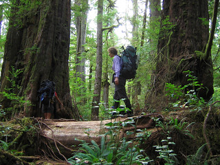
We emerged onto the top of the cliffs in obvious second-growth forest: lots of small skinny trees close together with little ground cover between them. Very unlike the dense forest that much of the trail is hacked out of. We were treated to occasional cliff-top views of calm, blue ocean (no whales though). After a short distance we descended into the real forest again, clambering over and ducking under fallen trees, passing by giant cedars. Before long we emerged on another beach, walking along until we reached Callicum Creek. Here we re-filled our water bottles since it would be the last water for a while (potentially for the rest of the trip).
Then we were back into the forest, then out onto a pocket beach, then back into the forest, etc. One of these gorgeous pocket beaches became our snack spot. Every morning after about an hour's walking, we all needed to stock up on the calories. This was a particularly nice beach, complete with a small shelter made by previous hikers. Now we had a good stretch of beach walking but it was easy going. Firm pebbles and gravel, occasional sand, some logs here and there. All the while hiking in the cool shade of the trees, admiring the westerly ocean view. Beautiful hiking conditions.
Getting up off (or down onto) the pocket beaches usually required scrambling up a small incline with the help of rope, rocks, tree roots etc. Yes, it's a flat hike overall but there are plenty of short climbs to ensure a full body workout! The trail markers were invariably fishing floats tied to the trees, occasionally adorned with such things as dead starfish.
Eventually we ran out of exciting climbs and we were up on the cliffs. It was cooler and breezier up here, clearly shown by the numerous twisted trees surrounding us. We passed many pocket beaches but with no way down. At several points the trail was right on the cliff edge, and within a few years I expect the trail will need to be re-routed through the trees again. As we got closer to Maquinna Point the rocks became very interesting. They were lava-like with very sharp edges. Not a place to fall over. In many places the surface of the rock was eroded away, leaving undercut miniature plateaux.
We passed through a gap between the cliffs and a headland which needed a combination of a rope and a chain to edge through so we wouldn't fall into the murky-looking pool below. Very Lord of the Rings :-) Then we came to another beach, and another scramble at the end to return to the forest. By now it was nearly lunchtime and we reached the turnoff to a small lake which could be used for fresh water. We ummed and ahhed for a bit, but decided to keep going, feeling that we had enough to last us. We pushed on to Maquinna Point with the aim of having lunch overlooking the sea.
Except when we got there it was so cold and windy that we stopped long enough to munch a quick snack and take a photo or two before heading back into the shelter of the trees. I was surprised by Maquinna Point: the cliffs were not as high as I expected. I guess I was thinking of the massive sea cliffs in the Orkneys when I read the descriptions but these were barely cliffs at all. Just offshore were a number of fishing boats – apparently the salmon fishing is good there.
So we headed back into the forest and decided to push on to the sea caves for lunch which were only another kilometre or so ahead of us. At one point we passed through a small swamp which at first seemed unremarkable but then we came to a patch festooned with gorgeous blue King Gentian flowers which stopped me in my tracks. Out came the camera :-) I think the others were a little hungrier than me as they had gone by the time I looked up! I spotted some sundew in amongst the swampy grass but couldn't get a good angle to take a photo.
Where were these sea caves? We were getting hungry and had taken a few wrong turns. If there's something I can pass on to future hikers it's pay attention to the trail markers! If they run out, you've taken the wrong trail! Just back up to the last marker and look for the next one. It works. It really works.
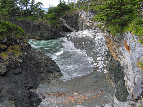
Before too long we descended again and stepped our way over fallen logs out onto a pebbly pocket beach. We had reached the sea caves! The setting was picturesque: small sea stacks and 30-foot cliffs enclosed a couple of pocket beaches. We found the entrance to the first cave and dropped our packs, pulling out the tent fly sheets to dry in the afternoon air. Time for lunch!
After lunch we explored the beach and found there were three caves. The main one we had first seen, a second smaller one at the top of the beach and a larger completely open cave. We considered that one since it was open at both ends but it was kinda draughty. The little one was too small so we decided on the centre cave. Inside it sloped upwards to the back of the cave. The floor was cool damp sand, and had many mouse and at least one set of wolf prints.
The only problem with that cave was the fact that the floor was on quite a slope. We made good use of some of the driftwood to level off the floor, banking it up at the front and excavating at the back to create a nice flat platform to pitch the tents. Brenda and Merewyn didn't quite spend as long on it as we did, and they still had a little slope. Surely that wouldn't be a problem though? Well, in any case they drew straws to see who would be the "squisher" and who the "squishee" that night :-)
Then we had another fine afternoon to explore the beach, read some more and generally chill out. I think we were all aware that it was the last full day of the hike and everyone was a little self-absorbed. I was happy to be there, but I could feel the first pangs of sadness that it would soon be over. But it was no time to think about the end of the trip: we were in a beautiful spot and there was nothing else to do but soak up the atmosphere, the feeling of serenity, being by the sea. I grew up next to the sea and I doubt I could ever live far from it.
Now for another rope-hanging experience! We cased out a good looking tree, tied a nice weighty piece of wood to the rope and once again yours truly took on the mantle of chief rope hurler :-) Strike one! I only just stepped out of the way as it came back down and thudded into the ground next to me. Strike two! I hit the underside of the branch I was aiming for and again had to dodge the returning lump of wood. Strike three! Bingo! Over the branch it sailed, like a thing of beauty before returning to earth with an ungraceful thump. Woohoo! What a feeling of accomplishment – or was it just relief at not humiliating myself in front of three women? I felt like I was starting to get the hang of this :-)
The day drew on, and suddenly it was dinner time again. Finally the food bags were beginning to feel light! Another great meal (!) followed by hot chocolate and the light was beginning to fade. We had one tea-light left and decided that tonight we would have another fire. This time we built a little fire ring from large pebbles, arranged a few pieces of wood for benches and set about collecting wood. And before long we had a lovely little fire.
The sun set, and darkness fell. We didn't need to get up quite as early in the morning so we stayed up enjoying the warmth from the fire. And dodging the smoke of course as the wind shifted every few seconds. But life felt good. In fact, life had been feeling good for the last few days. Even when I felt I couldn't take another step, it felt good to be there.
Now, after dark we discovered one of the "features" of camping on this beach. The sea was really loud reflecting off the cliffs. And so were your footsteps. Loud footsteps coupled with a small echo delay and suddenly it felt like you were being followed across the beach.... Very eery! Everyone used the ITF that night in record time. No one felt like lingering down near the water line.
We were just starting to wonder out loud about going to bed when the unthinkable happened. It started to rain! For the first time this week we felt water from the sky. It helped us make up our minds a little quicker and we retreated into the cave and our tents for our last night's sleep.
Monday, February 19, 2007
Day 4: Relaxing at Beano Creek
Something woke me up. Listen. Nope – must have been imagining things. Take a look outside to be sure. I unzipped the tent as quietly as I could and looked out. You know, words just can't convey the bit fat WOW I felt when I found myself staring into a beautiful starry sky. I almost dragged myself out just to enjoy it for a bit, but as usual I couldn't summon the enthusiasm to crawl out of my cosy sleeping bag. Besides, the gravel was remarkably comfortable.
Morning came eventually – but not at 6 am for once. Today was a rest day! I closed my eyes and dozed until I felt like getting up. I crawled out just as the sun peeked over the trees and spent some time just soaking up the morning before making a start on breakfast. Our bags had survived another night in a tree and I was relieved to see that we had no new holes in ours.
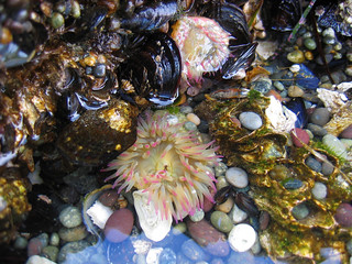
After breakfast we had the difficult choice of deciding how to relax first :-) Watching the incoming tide, we decided to explore the rocky outcrop before it was covered by the sea. I love being by the sea and exploring rock pools. Here we found loads of green sea anemones, occasionally a pink-fringed one and lots of star fish. At one point I picked up a hermit crab only for it to fall out of its shell! Oops! I set the shell back down next to the crab and it squeezed its way back inside. We could see why the sea otter fed at this location – the rocks were carpeted with barnacles and mussels.
The tide came in all too quickly and forced us back onto the beach. Time for catching up with some household chores. Laundry was done. Bodies were scrubbed and a sense of serenity fell over us. Merewyn spent the time sitting on her log reading White Slaves of Maquinna. The book tells the story of the time spent on Nootka Island by John Jewitt who was enslaved by Chief Maquinna for a couple of years in the late 18th Century. An interesting read, certainly if you're planning to do the Nootka Trail.
Funnily enough, on the one day we would have actually appreciated some sunshine it was cloudy and cool....
The sea otter came back at the same time as yesterday and we propped up the binoculars on a piece of wood so we could all watch it from time to time. Mesmerising :-)
Time passed. As did Air Nootka carrying the next batch of hikers, no doubt wondering why I was pointing the direction I was (ahem)... Still that's not as bad as Merewyn's stand-off yesterday with 2 guys on jet-skis!
Afternoon tea was made and we were joined by the owner of the Nootka Island Wilderness Retreat who stopped to chat for a bit. He told us how lucky we were that it had been dry this year making the Beano Creek crossing a no-brainer. He also teased us with tails of whales coming into the cove and running their bellies on the rocks. Waaa! We want to see whales!! (We later found out that they only do that in the spring so we weren't missing anything after all. We even later found out that sometimes they do come into the bay in the summer.)

More time passed and we summoned up the energy to cook our evening meal. After we'd eaten we set about making our first camp fire of the trip. We collected a pile of driftwood and used a tea-light candle to get the kindling to catch. Before long we were parked in front of a raging inferno and spent the better part of the next hour or so enjoying the smoke and embers. The disadvantage of synthetic clothing like fleece is that it melts when embers land on it... Both Brenda and I have souvenirs of that camp fire :-)
The fire was dying down nicely and we were all ready for bed when we were treated to more company. This time the owner of the land (and some of the cabins) behind us. Well, we had a nice chat and he told us everything he knew about the area (pretty much everything... :-) He was adamant that we should keep the fire going, eat some sunflower seeds (strangely he wasn't in a hurry to offer us some of his beer – that might have convinced me to stay up a little longer) and generally be sociable. Eventually his wife's sense of occasion prevailed and we all said goodnight. Nice enough people but we were on a schedule and we needed our sleep!
Morning came eventually – but not at 6 am for once. Today was a rest day! I closed my eyes and dozed until I felt like getting up. I crawled out just as the sun peeked over the trees and spent some time just soaking up the morning before making a start on breakfast. Our bags had survived another night in a tree and I was relieved to see that we had no new holes in ours.
After breakfast we had the difficult choice of deciding how to relax first :-) Watching the incoming tide, we decided to explore the rocky outcrop before it was covered by the sea. I love being by the sea and exploring rock pools. Here we found loads of green sea anemones, occasionally a pink-fringed one and lots of star fish. At one point I picked up a hermit crab only for it to fall out of its shell! Oops! I set the shell back down next to the crab and it squeezed its way back inside. We could see why the sea otter fed at this location – the rocks were carpeted with barnacles and mussels.
The tide came in all too quickly and forced us back onto the beach. Time for catching up with some household chores. Laundry was done. Bodies were scrubbed and a sense of serenity fell over us. Merewyn spent the time sitting on her log reading White Slaves of Maquinna. The book tells the story of the time spent on Nootka Island by John Jewitt who was enslaved by Chief Maquinna for a couple of years in the late 18th Century. An interesting read, certainly if you're planning to do the Nootka Trail.
Funnily enough, on the one day we would have actually appreciated some sunshine it was cloudy and cool....
The sea otter came back at the same time as yesterday and we propped up the binoculars on a piece of wood so we could all watch it from time to time. Mesmerising :-)
Time passed. As did Air Nootka carrying the next batch of hikers, no doubt wondering why I was pointing the direction I was (ahem)... Still that's not as bad as Merewyn's stand-off yesterday with 2 guys on jet-skis!
Afternoon tea was made and we were joined by the owner of the Nootka Island Wilderness Retreat who stopped to chat for a bit. He told us how lucky we were that it had been dry this year making the Beano Creek crossing a no-brainer. He also teased us with tails of whales coming into the cove and running their bellies on the rocks. Waaa! We want to see whales!! (We later found out that they only do that in the spring so we weren't missing anything after all. We even later found out that sometimes they do come into the bay in the summer.)
More time passed and we summoned up the energy to cook our evening meal. After we'd eaten we set about making our first camp fire of the trip. We collected a pile of driftwood and used a tea-light candle to get the kindling to catch. Before long we were parked in front of a raging inferno and spent the better part of the next hour or so enjoying the smoke and embers. The disadvantage of synthetic clothing like fleece is that it melts when embers land on it... Both Brenda and I have souvenirs of that camp fire :-)
The fire was dying down nicely and we were all ready for bed when we were treated to more company. This time the owner of the land (and some of the cabins) behind us. Well, we had a nice chat and he told us everything he knew about the area (pretty much everything... :-) He was adamant that we should keep the fire going, eat some sunflower seeds (strangely he wasn't in a hurry to offer us some of his beer – that might have convinced me to stay up a little longer) and generally be sociable. Eventually his wife's sense of occasion prevailed and we all said goodnight. Nice enough people but we were on a schedule and we needed our sleep!
Thursday, January 04, 2007
Day 3: Calvin Falls to Beano Creek
Aaaah - what a relaxing night's sleep! The sound of the waterfall was soothing, the gravel remarkably comfortable. I opened my eyes a few minutes before the alarm went off and hauled myself out of my sleeping bag. I rolled and packed my bedding to get moving and warm up a little. Another clear blue sky greeted me as I left the tent for the usual morning ritual.
On collecting the food bags I noticed that ours had been nibbled in the night. Not only that, the critters responsible had left their calling card! Ewww! Why can't they use the ITF? Yuck. I guess the rope was too thick and the mice/voles/squirrels were able to descend it from the tree and tackle the swinging bounty. Pah. Forget the bears - it's the little rodents that are the real nuisance!
Back at camp, the others were stirring and it was time to start get the stove on and sort out breakfast. With coffee in hand, we packed away the tent and reloaded our packs. As we were taking down the tent, we found our bottle of sun screen which we had forgotten to put into our food bags. The zip-lock bag was chewed through and there were teeth marks in the plastic! Hmmm. Better not make that mistake again. Maria said she thought she had heard noises beside her in the night...
By 8 am we were ready to set off. We weren't looking forward to the latter half of today's hiking with the infamous pea-gravel looming large in our minds. That was to come. The first challenge was actually getting across Calvin Creek, even at low tide. Near the camp site it was far too deep to wade with boots on so we walked down the beach across the sand to where it spread out into a shallow braided mini-river. But even here the water ran fairly quickly and was just a little too deep to step through without getting some down into your boots. So the three ladies undid their freshly laced boots and waded through barefoot. I was too lazy to do that and tried to skip my way through the shallowest part I could find. I forgot that I was carrying an extra 50 lbs in weight and my light-footed hops were more like lurching squelches into the wet sand. Still, I managed to get over without getting water in my boots (it splashed all up my legs instead).
From there it was easy hiking on firm damp sand. We made excellent progress, passing the surfers' tents (whom I forgot to mention in yesterday's write up) and reaching the next headland in what felt like no time at all. Gradually we ran out of beach and we found ourselves picking our way over rocks. That started out OK, but then we came to the worst bit: an unbroken expanse of football-sized rocks most of which were (to quote another hiker) as slippery as snot. And they weren't kidding! Despite looking dry and firm, it was like walking on ice and I almost fell several times. Now would have been a good time to use the hiking poles (and Maria did use hers) but as usual I was just too lazy :-)
Now we were faced with two choices: either head up the beach on to larger, flatter and less slippery rocks or go out on the wet-and-weedy tidal shelf. Brenda opted for the shelf, donning aqua socks and her sandals (lacing her boots to her pack). Merewyn went for the rocks. Maria and I weren't sure so we tried the rocks, almost fell a few times, then headed out to the shelf. Except it was really too wet for boots so we picked our way back over the snotty rocks to the bigger ones at the top of the beach. By now we had fallen quite a way behind the other two and the conditions weren't conducive to making up lost time. So the hike became just a steady plod, trying to maintain balance (and a sense of humour!) and not lose any more ground over the other two.
After what seemed like an age (what? it was only an hour?), we reached Bajo point. By now we had managed to pick our way down onto the shelf again as it was better than earlier. Within a few minutes we caught up with Brenda and Merewyn and promptly dropped our packs to dig out some sustenance. Bajo point has a small sea-stack a hundred yards or so off shore but the tide was coming in too fast for us to explore any further. We decided to rest a little longer and watched a couple of seals float in on the tide.
As we were getting ready to go we heard Brenda exclaim "Oh crap!!". We turned to see what had happened saw her looking in disbelief at her pack. There was only 1 hiking boot laced to it. Oh crap indeed. Here we were, barely half-way through a 37-km hike with the hardest hiking to do and one of our group has only 1 boot. We spent a few minutes back-tracking along the beach looking for it but quickly realized that it was a hopeless task.
To calm ourselves we explored the site of the First Nations village on Bajo Point. In amongst the trees, the sound of the sea was suddenly very distant. There wasn't much to see as nature had reclaimed the site, although it was clearly more open than most of the surrounding forest.
Time to move on. The next 3 hours would last forever for me. Once round Bajo Point we were now walking in full hot sunshine in the middle of the day. And we had our first encounter with pea gravel. OMFG. Thankfully it was only a short distance and we were soon able to head back out onto the tidal shelf. Despite being wet and weedy it was infinitely better than the beach. After an hour or so we stopped for lunch; I grabbed the only bit of shade I could see and welcomed the chance to get out of the baking sun.
Over lunch we had our first whale encounter: Brenda and I saw a couple of spouts on the horizon. Getting excited we stopped and scanned for more but that was it. Unfortunately, it was also our last whale encounter of the trip :-(
After lunch we headed back out onto the tidal shelf to pick our way through the weed and shallow pools. Even though it wasn't easy walking, it was at least firm and not as slippery as expected. (It's odd how seaweed could be less slippery than rock...) We were still hiking in the heat of the day, and the sun reflected strongly off the water. At one point we came across a three-sided rock that was the perfect height for three of us to balance our packs on and rest our shoulders. Guess which three :-)
But all good things must come to an end and the rising tide eventually forced us onto the dreaded pea gravel. What can I say? I guess we had to be thankful that the tide had been out for much of the day and we "only" had about 45 minutes to an hour of slogging on the gravel. Other hikers had tipped us off about using gaiters on this stretch – they really did help prevent the gravel getting into your boots. Highly recommended.
Finally we turned a corner and suddenly realized we were at Beano Creek. But where was the creek? As we made our way up the steep gravel banks we saw that we had already crossed the creek – on the beach. Wow, what a stroke of luck! The gravel was banked up over the mouth of the creek and we didn't have to wade or wait to cross it. In years past, other hikers have had to swim across or wait days for the level to drop.
We decided to pitch our tents on the flat area above the winter storm line, behind a couple of massive logs, nay, full-grown trees. We dropped our packs and pulled out the tent flysheets to dry off in the afternoon sun and breeze. Then I made a comfy patch in the gravel (in the shade of course), pulled my baseball cap over my eyes and slept for half an hour. I was utterly exhausted – I don't remember the last time I was so physically tired. At some point Maria joined me and Merewyn got a cheeky photo of the two of us laid out on the beach. Thanks Mere :-)
Eventually we came round, and decided it was time for afternoon tea. While boiling the water, we watched the tide come in round a flat rocky outcrop off the point. Then I spotted some movement and saw in the binoculars that we had a real, live sea otter dining in sight of our camp! Wow!! It was fabulous to watch the otter dive under, return to the surface, and, lying on its back, use a stone to break open whatever shellfish it had plucked from the bottom. Occasionally large waves would break over it but it wasn't fazed. What a treat! It spent an hour or more feeding at this spot before swimming off.
With Beano Creek dammed and the tide coming in, I was worried that the creek water would be brackish and not drinkable. So to get fresh water we waded upstream a bit. We needn't have worried though as the water was totally fresh, not even a hint of salt. Returning to camp it was getting on for dinner time. We made up a nice kitchen area with driftwood benches and settled down to hot food.
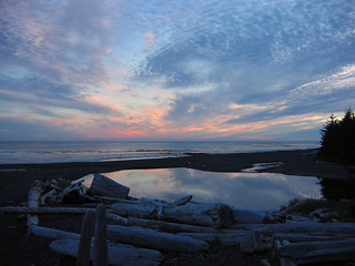
We watched the clouds turn pink as the sun set, and it was time to hang our food. No convenient ropes tonight though – it was up to us to use our own (well, Brenda's) rope. Fortunately along the top of the beach there was a suitable (dead) tree with branches just high enough off the ground and just spindly enough to not take the weight of a large mammal. Now to sling the rope over. That was where I came in :-) I stood on an small embankment at the base of the tree and hurled the rope (with a small piece of wood attached for weight) skywards in the vain hope of getting it over the right branch. My first attempt resulted in me almost cracking my own bones as I fell backwards off the embankment and into the tree, bruising my back on the little pointy broken-off branches. My second attempt almost took out one of the others (they took an extra step back after that). Third time lucky! Not this time. I almost got it in the right place but it got caught in a bough and we couldn't haul up the food bags. OK maybe fourth time lucky? Yes! Exactly the right place! And before we knew it, our food was stored. We remembered to include the sun screen this time....
With the last light fading we all headed for our sleeping bags and a well-deserved night's sleep.
On collecting the food bags I noticed that ours had been nibbled in the night. Not only that, the critters responsible had left their calling card! Ewww! Why can't they use the ITF? Yuck. I guess the rope was too thick and the mice/voles/squirrels were able to descend it from the tree and tackle the swinging bounty. Pah. Forget the bears - it's the little rodents that are the real nuisance!
Back at camp, the others were stirring and it was time to start get the stove on and sort out breakfast. With coffee in hand, we packed away the tent and reloaded our packs. As we were taking down the tent, we found our bottle of sun screen which we had forgotten to put into our food bags. The zip-lock bag was chewed through and there were teeth marks in the plastic! Hmmm. Better not make that mistake again. Maria said she thought she had heard noises beside her in the night...
By 8 am we were ready to set off. We weren't looking forward to the latter half of today's hiking with the infamous pea-gravel looming large in our minds. That was to come. The first challenge was actually getting across Calvin Creek, even at low tide. Near the camp site it was far too deep to wade with boots on so we walked down the beach across the sand to where it spread out into a shallow braided mini-river. But even here the water ran fairly quickly and was just a little too deep to step through without getting some down into your boots. So the three ladies undid their freshly laced boots and waded through barefoot. I was too lazy to do that and tried to skip my way through the shallowest part I could find. I forgot that I was carrying an extra 50 lbs in weight and my light-footed hops were more like lurching squelches into the wet sand. Still, I managed to get over without getting water in my boots (it splashed all up my legs instead).
From there it was easy hiking on firm damp sand. We made excellent progress, passing the surfers' tents (whom I forgot to mention in yesterday's write up) and reaching the next headland in what felt like no time at all. Gradually we ran out of beach and we found ourselves picking our way over rocks. That started out OK, but then we came to the worst bit: an unbroken expanse of football-sized rocks most of which were (to quote another hiker) as slippery as snot. And they weren't kidding! Despite looking dry and firm, it was like walking on ice and I almost fell several times. Now would have been a good time to use the hiking poles (and Maria did use hers) but as usual I was just too lazy :-)
Now we were faced with two choices: either head up the beach on to larger, flatter and less slippery rocks or go out on the wet-and-weedy tidal shelf. Brenda opted for the shelf, donning aqua socks and her sandals (lacing her boots to her pack). Merewyn went for the rocks. Maria and I weren't sure so we tried the rocks, almost fell a few times, then headed out to the shelf. Except it was really too wet for boots so we picked our way back over the snotty rocks to the bigger ones at the top of the beach. By now we had fallen quite a way behind the other two and the conditions weren't conducive to making up lost time. So the hike became just a steady plod, trying to maintain balance (and a sense of humour!) and not lose any more ground over the other two.
After what seemed like an age (what? it was only an hour?), we reached Bajo point. By now we had managed to pick our way down onto the shelf again as it was better than earlier. Within a few minutes we caught up with Brenda and Merewyn and promptly dropped our packs to dig out some sustenance. Bajo point has a small sea-stack a hundred yards or so off shore but the tide was coming in too fast for us to explore any further. We decided to rest a little longer and watched a couple of seals float in on the tide.
As we were getting ready to go we heard Brenda exclaim "Oh crap!!". We turned to see what had happened saw her looking in disbelief at her pack. There was only 1 hiking boot laced to it. Oh crap indeed. Here we were, barely half-way through a 37-km hike with the hardest hiking to do and one of our group has only 1 boot. We spent a few minutes back-tracking along the beach looking for it but quickly realized that it was a hopeless task.
To calm ourselves we explored the site of the First Nations village on Bajo Point. In amongst the trees, the sound of the sea was suddenly very distant. There wasn't much to see as nature had reclaimed the site, although it was clearly more open than most of the surrounding forest.
Time to move on. The next 3 hours would last forever for me. Once round Bajo Point we were now walking in full hot sunshine in the middle of the day. And we had our first encounter with pea gravel. OMFG. Thankfully it was only a short distance and we were soon able to head back out onto the tidal shelf. Despite being wet and weedy it was infinitely better than the beach. After an hour or so we stopped for lunch; I grabbed the only bit of shade I could see and welcomed the chance to get out of the baking sun.
Over lunch we had our first whale encounter: Brenda and I saw a couple of spouts on the horizon. Getting excited we stopped and scanned for more but that was it. Unfortunately, it was also our last whale encounter of the trip :-(
After lunch we headed back out onto the tidal shelf to pick our way through the weed and shallow pools. Even though it wasn't easy walking, it was at least firm and not as slippery as expected. (It's odd how seaweed could be less slippery than rock...) We were still hiking in the heat of the day, and the sun reflected strongly off the water. At one point we came across a three-sided rock that was the perfect height for three of us to balance our packs on and rest our shoulders. Guess which three :-)
But all good things must come to an end and the rising tide eventually forced us onto the dreaded pea gravel. What can I say? I guess we had to be thankful that the tide had been out for much of the day and we "only" had about 45 minutes to an hour of slogging on the gravel. Other hikers had tipped us off about using gaiters on this stretch – they really did help prevent the gravel getting into your boots. Highly recommended.
Finally we turned a corner and suddenly realized we were at Beano Creek. But where was the creek? As we made our way up the steep gravel banks we saw that we had already crossed the creek – on the beach. Wow, what a stroke of luck! The gravel was banked up over the mouth of the creek and we didn't have to wade or wait to cross it. In years past, other hikers have had to swim across or wait days for the level to drop.
We decided to pitch our tents on the flat area above the winter storm line, behind a couple of massive logs, nay, full-grown trees. We dropped our packs and pulled out the tent flysheets to dry off in the afternoon sun and breeze. Then I made a comfy patch in the gravel (in the shade of course), pulled my baseball cap over my eyes and slept for half an hour. I was utterly exhausted – I don't remember the last time I was so physically tired. At some point Maria joined me and Merewyn got a cheeky photo of the two of us laid out on the beach. Thanks Mere :-)
Eventually we came round, and decided it was time for afternoon tea. While boiling the water, we watched the tide come in round a flat rocky outcrop off the point. Then I spotted some movement and saw in the binoculars that we had a real, live sea otter dining in sight of our camp! Wow!! It was fabulous to watch the otter dive under, return to the surface, and, lying on its back, use a stone to break open whatever shellfish it had plucked from the bottom. Occasionally large waves would break over it but it wasn't fazed. What a treat! It spent an hour or more feeding at this spot before swimming off.
With Beano Creek dammed and the tide coming in, I was worried that the creek water would be brackish and not drinkable. So to get fresh water we waded upstream a bit. We needn't have worried though as the water was totally fresh, not even a hint of salt. Returning to camp it was getting on for dinner time. We made up a nice kitchen area with driftwood benches and settled down to hot food.
We watched the clouds turn pink as the sun set, and it was time to hang our food. No convenient ropes tonight though – it was up to us to use our own (well, Brenda's) rope. Fortunately along the top of the beach there was a suitable (dead) tree with branches just high enough off the ground and just spindly enough to not take the weight of a large mammal. Now to sling the rope over. That was where I came in :-) I stood on an small embankment at the base of the tree and hurled the rope (with a small piece of wood attached for weight) skywards in the vain hope of getting it over the right branch. My first attempt resulted in me almost cracking my own bones as I fell backwards off the embankment and into the tree, bruising my back on the little pointy broken-off branches. My second attempt almost took out one of the others (they took an extra step back after that). Third time lucky! Not this time. I almost got it in the right place but it got caught in a bough and we couldn't haul up the food bags. OK maybe fourth time lucky? Yes! Exactly the right place! And before we knew it, our food was stored. We remembered to include the sun screen this time....
With the last light fading we all headed for our sleeping bags and a well-deserved night's sleep.
Wednesday, November 08, 2006
Day 2: Third Beach to Calvin Falls
Off went the alarm at 6 am and I dragged myself out of my sleeping bag. It had been a restless first night – was this the start of a pattern? Scurrying noises had kept me awake and there were plenty of tiny footprints all around our tent. But thankfully no big ones.
A beautiful crystal-clear morning and the first task was to make use of the ITF. Then it was off to collect the food bags. I must have been paranoid about the rope coming loose as it took ages to undo all the knots and loops I'd made last night! When I eventually retrieved the bags (all fine) I carried them back to camp to find the others stirring.
Breakfast was followed by breaking camp, shaking the dew off the flysheets and repacking the backpacks. By 8.20 am we were loaded and ready to go. It felt fresh and cool walking over the sand before the sun had risen over the trees.
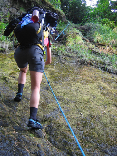
We reached the end of the beach and faced our first challenge of the day: a 30-foot climb up a steep, root-and-fern covered slope. A rope was there to help but it wasn't entirely necessary. That accomplished, we immediately began climbing over and scrambling under fallen trees. Within 20 minutes though we came out of the forest onto another sandy beach, around the headland from Third Beach. The tide was low and we had a large expanse of firm sand to walk on – just perfect.
Soon the beach became rockier and before long we were up at the high-tide line walking through the grass and rocks rather then picking our way over numerous little boulders. Along this stretch we settled into a comfortable stride, pausing after an hour to supplement breakfast with a Clif bar.
Setting off again, we came to the best hiking yet – a solid, level tidal shelf which was free of seaweed. Dozens of small shore crabs scuttled around our feet, threatening violent reprisal with a wave of their claws. Brenda picked one up and it reminded us of the crabs in Finding Nemo: "Heyyy, heyyy".
More tidal shelf, more panoramic views out to sea and more steady progress. At times we had to pick our way through dried seaweed which was pretty smelly. The abundance of bear poo suggested that they like to eat seaweed. No bear sightings, but before long we spotted a set of bear tracks in the sand. To our relief they were heading back the way we had just come. But after a while we noticed that there were now two sets of tracks, and they were heading the same direction as us. We kept our eyes and ears open but still saw no bears.
The long sandy crescent of Skuna Bay came and went. The next hurdle turned out to be no hurdle at all. We were racing against the tide to get round the headlands before Calvin Falls (which was why we were getting up at 6 am) and we weren't sure where the tide would be at the time we got there. The tide was still a long way out, despite coming in rapidly and we made it round safely. But be warned: there was nowhere to go if the tide had come in. The high-tide line was the cliffs, and although they weren't very high (maybe 20-30 feet), they were high enough to stop you getting off the beach.
We made it round the headland with plenty of time to spare, and we were back on firm sand. By now I was getting tired and we had a short break. Strangely there was absolutely no sign of Calvin Falls. Were we as far along as we though we were? It was sometimes hard to tell and even after some discussion it wasn't clear that everyone was 100% sure where we were! We set off again along the beach, wondering to each other where the falls were.
Just as we were beginning to doubt our progress, we came to a curve in the beach and suddenly there were Calvin Falls. Yay! We all cheered. The book suggested that the best camping was on the south side of the creek. Although the tide was not high, the creek was deep enough to look a bit daunting to wade through with a full pack. So we stopped on the north side (next to the frame of a shelter) and had our lunch.
After lunch we decided that we were actually more than happy with the camping options on the north side and pitched our tents. Brenda and Merewyn put theirs within the shelter frame (no roof though). Someone had draped seaweed over the frame, which made it look like it was decorated with Christmas lights. With flysheets laid out to dry in the sun we set about relaxing. Brenda and Merewyn opted for another dip in the ocean and after some squealing (one of my enduring memories :-) they made it in. But not for long, and soon they headed for the pool beneath Calvin Falls. Maria joined them (I was too cowardly as the water felt cold and I didn't fancy another rash) and I got a great photo of the three of them under the falls. Despite the warm sun, everyone had a hot drink after their dip.
Wow – what to do with the rest of the day? A bit of exploring here and there was in order. I went over to the south side, bravely wading the creek (ha ha) to investigate a hanging rope for food storage. It turned out to be not high enough off the ground, but I did find a small hammock made from fishing net which I made use of for a quick nap. Brenda and Merewyn explored the top of the falls, as did I a bit later (easy to get up, not so easy to get down on the crumbly rock). The view from the top of the falls wasn't much better than being on the beach and it really wasn't worth going up there.
In the meantime Merewyn had found a bigger and better shelter in the trees a few yards further north from our tents. I made my way back and we all investigated. The best thing was it had a large fixed rope, neatly solving our food storage problem. The shelter was amazing, complete with a double hammock. Plenty of people had stayed there, some of them at less hospitable times of the year. Names and dates were carved in or written on every available piece of wood or float. We found a pen (!) and proudly added our names to a plastic float.
The sun was getting lower in the sky and we decided to prepare dinner a little earlier than last night. That done, we refilled our water containers, stowed our food and as the sun went down, headed into our tents.
A beautiful crystal-clear morning and the first task was to make use of the ITF. Then it was off to collect the food bags. I must have been paranoid about the rope coming loose as it took ages to undo all the knots and loops I'd made last night! When I eventually retrieved the bags (all fine) I carried them back to camp to find the others stirring.
Breakfast was followed by breaking camp, shaking the dew off the flysheets and repacking the backpacks. By 8.20 am we were loaded and ready to go. It felt fresh and cool walking over the sand before the sun had risen over the trees.
We reached the end of the beach and faced our first challenge of the day: a 30-foot climb up a steep, root-and-fern covered slope. A rope was there to help but it wasn't entirely necessary. That accomplished, we immediately began climbing over and scrambling under fallen trees. Within 20 minutes though we came out of the forest onto another sandy beach, around the headland from Third Beach. The tide was low and we had a large expanse of firm sand to walk on – just perfect.
Soon the beach became rockier and before long we were up at the high-tide line walking through the grass and rocks rather then picking our way over numerous little boulders. Along this stretch we settled into a comfortable stride, pausing after an hour to supplement breakfast with a Clif bar.
Setting off again, we came to the best hiking yet – a solid, level tidal shelf which was free of seaweed. Dozens of small shore crabs scuttled around our feet, threatening violent reprisal with a wave of their claws. Brenda picked one up and it reminded us of the crabs in Finding Nemo: "Heyyy, heyyy".
More tidal shelf, more panoramic views out to sea and more steady progress. At times we had to pick our way through dried seaweed which was pretty smelly. The abundance of bear poo suggested that they like to eat seaweed. No bear sightings, but before long we spotted a set of bear tracks in the sand. To our relief they were heading back the way we had just come. But after a while we noticed that there were now two sets of tracks, and they were heading the same direction as us. We kept our eyes and ears open but still saw no bears.
The long sandy crescent of Skuna Bay came and went. The next hurdle turned out to be no hurdle at all. We were racing against the tide to get round the headlands before Calvin Falls (which was why we were getting up at 6 am) and we weren't sure where the tide would be at the time we got there. The tide was still a long way out, despite coming in rapidly and we made it round safely. But be warned: there was nowhere to go if the tide had come in. The high-tide line was the cliffs, and although they weren't very high (maybe 20-30 feet), they were high enough to stop you getting off the beach.
We made it round the headland with plenty of time to spare, and we were back on firm sand. By now I was getting tired and we had a short break. Strangely there was absolutely no sign of Calvin Falls. Were we as far along as we though we were? It was sometimes hard to tell and even after some discussion it wasn't clear that everyone was 100% sure where we were! We set off again along the beach, wondering to each other where the falls were.
Just as we were beginning to doubt our progress, we came to a curve in the beach and suddenly there were Calvin Falls. Yay! We all cheered. The book suggested that the best camping was on the south side of the creek. Although the tide was not high, the creek was deep enough to look a bit daunting to wade through with a full pack. So we stopped on the north side (next to the frame of a shelter) and had our lunch.
After lunch we decided that we were actually more than happy with the camping options on the north side and pitched our tents. Brenda and Merewyn put theirs within the shelter frame (no roof though). Someone had draped seaweed over the frame, which made it look like it was decorated with Christmas lights. With flysheets laid out to dry in the sun we set about relaxing. Brenda and Merewyn opted for another dip in the ocean and after some squealing (one of my enduring memories :-) they made it in. But not for long, and soon they headed for the pool beneath Calvin Falls. Maria joined them (I was too cowardly as the water felt cold and I didn't fancy another rash) and I got a great photo of the three of them under the falls. Despite the warm sun, everyone had a hot drink after their dip.
Wow – what to do with the rest of the day? A bit of exploring here and there was in order. I went over to the south side, bravely wading the creek (ha ha) to investigate a hanging rope for food storage. It turned out to be not high enough off the ground, but I did find a small hammock made from fishing net which I made use of for a quick nap. Brenda and Merewyn explored the top of the falls, as did I a bit later (easy to get up, not so easy to get down on the crumbly rock). The view from the top of the falls wasn't much better than being on the beach and it really wasn't worth going up there.
In the meantime Merewyn had found a bigger and better shelter in the trees a few yards further north from our tents. I made my way back and we all investigated. The best thing was it had a large fixed rope, neatly solving our food storage problem. The shelter was amazing, complete with a double hammock. Plenty of people had stayed there, some of them at less hospitable times of the year. Names and dates were carved in or written on every available piece of wood or float. We found a pen (!) and proudly added our names to a plastic float.
The sun was getting lower in the sky and we decided to prepare dinner a little earlier than last night. That done, we refilled our water containers, stowed our food and as the sun went down, headed into our tents.
Friday, September 29, 2006
Day 1: Gold River to Third Beach
Setting the trend for the next few days, the alarm went off at 6am. We packed our tents, piled our stuff into the car and headed for Gold River. We reached the town within half an hour and before we knew it, we were out the other side, heading for the Air Nootka dock. After passing a deer grazing at the roadside, we were slowed to a crawl by a logging truck. After what seemed like an age we managed to pass the truck and we found the plane terminal. OK, nowhere to eat here so we headed back to Gold River and went to find the Manila Grill, now called Lucy's Cafe. Big breakfasts all round! Lumberjack platter for me - 2 eggs, 2 sausages, 2 strips of bacon and 2 pancakes :-) I thought I'd end up leaving some but nooo, I had no problem putting it away.
Feeling suitably well-fed and relaxed, we headed back down to the Air Nootka terminal where the Gold River enters the deep-water fjord of the Muchalat Inlet. We parked up and dragged our packs over to the office and checked in. We paid for our flights and paid the $40 trail access fee for Friendly Cove, carefully stowing away the receipt for when we would have to show it. We weighed our packs, just to see who's was the heaviest. It was a tie between myself and Brenda at 51 lbs. We sat around in the sunshine waiting for our plane to return from an earlier sightseeing trip. Just after 12 noon, it landed and we took ourselves down onto the dock to load up.
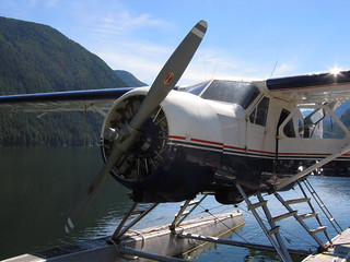
This was going to be the first flight in such a small aircraft for me - I'd only flown in large passenger planes before, the smallest being a 50-seater twin turbo-prop. Now it was time to get into our single-engine de Havilland DHC-2 Beaver, which seats up to 5 (+ pilot), callsign C-FOXD. We drew straws to see who would get the co-pilot seat: Merewyn won and could hardly wait to get in. We took our seats and donned our headphones. With cameras at the ready, we taxied away from the dock (only to turn round briefly and drop off the sunglasses of one of the previous passengers) and with everything checked out, the pilot opened the throttle and we were on our way.
What a great flight! A silky smooth take-off followed by a gentle climb and we were up to our cruising altitude of a mere 500 feet at an airspeed of 110 knots, the engine ticking over at 2000 rpm. Our pilot was great, pointing out all manner of interesting stuff along the way: schools of fish, fish farms, logging operations and the red tide. We even got a quick demonstration of how powerful thermals are: flying over one of the small islands the plane was accelerated sharply upwards for a few seconds before dropping back down again. That was fun :-)
We reached the end of Muchalat Inlet after about 15 minutes, entered Nootka Sound and banked right over Friendly Cove. This put us on a path parallel with the coastline and for the next 20 minutes or so we watched beach after beach drift past, giving us a preview of what we would experience over the next few days. Suddenly 37 km looked like a very long way! But the beaches looked spectacular: cobbles, pebbles, sand, intertidal shelf and rocky headlands. We passed the sea caves which we camped in on our last night; Beano Creek (which was blocked by a new beach); Bajo Point (the only spot where we could be picked up if we ran into trouble); Calvin Falls; and finally, Third Beach. All these places we had read about were now a reality.
After passing Third Beach, we flew over the north-west tip of Nootka Island (and the wreck of an old freighter), banked right and began a short, steep descent into Louie Lagoon. The landing was as smooth as, if not smoother than, the take-off – I was amazed at just how smooth the landing was! The plane decelerated, and the pilot cut the engine, allowing the plane to drift towards the shore. He was obviously well-practiced because the plane slowed perfectly to a crawl before beaching gently on the shore.
Once we had stopped I stepped out and plopped down into the knee-deep water, narrowly missing an enormous starfish. One by one the others got out of the plane and we unloaded our packs onto the tiny patch of "beach" which marked the trailhead. Once safely unloaded I pushed back and spun round the plane so it was pointed in the right direction for the pilot to take off. We thanked him and watched him set off down the lagoon. (Beaver engines have a great and distinctive sound.)
Within a minute or so all was quiet and we stood around looking at each other. For the first time, the reality of our situation sank in. Big time! We were on our own out there and the only way home was to our own leg power. Putting off the inevitable, we spent a good 20 minutes looking at and taking photos of starfish. Now we knew why Louie Lagoon is also known as Starfish Lagoon!
Eventually we figured it was time to move on so we dried our feet, put on our boots and hefted our packs onto our backs. Time for a group photo! :-) As we were setting up, a mink paid us a brief but inquisitive visit. Then it was time to get started and we set off into the forest.
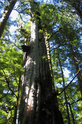
And what forest! The trail was well-marked with orange markers but the density of the surrounding vegetation was incredible. The trail was the only way through the forest – it was simply impossible to even think about heading off trail due to the amount of thick salal, small trees and fallen larger trees. Welcome to mature old-growth forest! Within a few metres the tone was set for the next few days of forest hiking, as we ducked under and clambered over several blown down trees. We passed and marvelled at numerous huge old cedars. Impressive to look at but unfortunately impossible to photograph. It just doesn't do them justice.
We knew we only had 1 km or so to hike, but it felt like a very long kilometre. I think we were all wondering if we had it in us to do this for 5 days. However, 35 minutes later we heard the sea and, passing under a large cliff, we emerged onto Third Beach.
And what a beach! We'd seen it already from the air perhaps an hour or so ago but to see it close up was a different experience. We crossed a small creek (with wolf-prints galore in the mud) and walked out into bright warm sunshine on white sand. We walked up the beach, around a lagoon and decided on our camping spot. We dropped our packs and pulled out lunch.
All the trepidation of Louie Lagoon evaporated. We couldn't believe where we were and that we had it all to ourselves! What a beautiful spot. We pitched our tents and had only one thought on our minds: time for a swim. Merewyn and Brenda went first and all we could hear of them was the occasional squeal – the water was not as warm as it looked! Maria and I soon joined them and braved the chilly seas.
The water was beautifully clear. I saw fish swimming near me and I wished for my mask and snorkel. Eventually we hauled ourselves out and dried off. Within a couple of minutes I noticed that I had a rash on my arm. Then I saw it was on my body, legs. Then, like the kid in "Stand By Me" after they'd encountered the leeches, I had one last place to check. Yup, it was everywhere. I didn't remember getting stung by anything and it wasn't itchy or painful. I took some antihistamine and went over to the creek to wash off. It had disappeared within an hour. I have no idea what caused it.
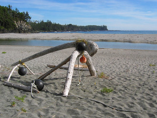
Dry and comfortable, it was time to explore the beach a little. Maria had found a hammock and some decorative beach art made from driftwood and floats. We went to the south end of the beach, walking along the tide-line scattering little beach-hoppers at every step. These little shrimp-like creatures had a nasty habit of getting between your toes and your footwear, with the inevitable occasional squish – I couldn't eat prawns for ages after that. We found more wolf prints and plenty of mouse prints in the sand, but there was no life to be seen. Walking back up to the north end of the beach we saw a bald eagle fly over, and another landed in a nearby tree. This end of the beach had great rock pools to explore as the tide went out, which were full of sea-stars, anemones, crabs and small fish.
Dinner time came and we cooked our first meal, sitting back in comfort on the sand. We had miscalculated a little though and it was getting dark by the time we had cleaned up. The lure of taking sunset photographs had been just too strong :-) Only then did we think of looking for somewhere to hang our food for the night! With headlamps at the ready, and hoping that we weren't going to encounter any large and pointy-clawed wildlife we set off to the place with the hammock where we'd seen a rope slung over a high branch. We couldn't really judge what we were doing in the dark but at least our food was well above the ground and far from our tents.
Satisfied, and with our alarms set for 6am, we crawled into our tents and settled down to sleep. What a day!
Feeling suitably well-fed and relaxed, we headed back down to the Air Nootka terminal where the Gold River enters the deep-water fjord of the Muchalat Inlet. We parked up and dragged our packs over to the office and checked in. We paid for our flights and paid the $40 trail access fee for Friendly Cove, carefully stowing away the receipt for when we would have to show it. We weighed our packs, just to see who's was the heaviest. It was a tie between myself and Brenda at 51 lbs. We sat around in the sunshine waiting for our plane to return from an earlier sightseeing trip. Just after 12 noon, it landed and we took ourselves down onto the dock to load up.
This was going to be the first flight in such a small aircraft for me - I'd only flown in large passenger planes before, the smallest being a 50-seater twin turbo-prop. Now it was time to get into our single-engine de Havilland DHC-2 Beaver, which seats up to 5 (+ pilot), callsign C-FOXD. We drew straws to see who would get the co-pilot seat: Merewyn won and could hardly wait to get in. We took our seats and donned our headphones. With cameras at the ready, we taxied away from the dock (only to turn round briefly and drop off the sunglasses of one of the previous passengers) and with everything checked out, the pilot opened the throttle and we were on our way.
What a great flight! A silky smooth take-off followed by a gentle climb and we were up to our cruising altitude of a mere 500 feet at an airspeed of 110 knots, the engine ticking over at 2000 rpm. Our pilot was great, pointing out all manner of interesting stuff along the way: schools of fish, fish farms, logging operations and the red tide. We even got a quick demonstration of how powerful thermals are: flying over one of the small islands the plane was accelerated sharply upwards for a few seconds before dropping back down again. That was fun :-)
We reached the end of Muchalat Inlet after about 15 minutes, entered Nootka Sound and banked right over Friendly Cove. This put us on a path parallel with the coastline and for the next 20 minutes or so we watched beach after beach drift past, giving us a preview of what we would experience over the next few days. Suddenly 37 km looked like a very long way! But the beaches looked spectacular: cobbles, pebbles, sand, intertidal shelf and rocky headlands. We passed the sea caves which we camped in on our last night; Beano Creek (which was blocked by a new beach); Bajo Point (the only spot where we could be picked up if we ran into trouble); Calvin Falls; and finally, Third Beach. All these places we had read about were now a reality.
After passing Third Beach, we flew over the north-west tip of Nootka Island (and the wreck of an old freighter), banked right and began a short, steep descent into Louie Lagoon. The landing was as smooth as, if not smoother than, the take-off – I was amazed at just how smooth the landing was! The plane decelerated, and the pilot cut the engine, allowing the plane to drift towards the shore. He was obviously well-practiced because the plane slowed perfectly to a crawl before beaching gently on the shore.
Once we had stopped I stepped out and plopped down into the knee-deep water, narrowly missing an enormous starfish. One by one the others got out of the plane and we unloaded our packs onto the tiny patch of "beach" which marked the trailhead. Once safely unloaded I pushed back and spun round the plane so it was pointed in the right direction for the pilot to take off. We thanked him and watched him set off down the lagoon. (Beaver engines have a great and distinctive sound.)
Within a minute or so all was quiet and we stood around looking at each other. For the first time, the reality of our situation sank in. Big time! We were on our own out there and the only way home was to our own leg power. Putting off the inevitable, we spent a good 20 minutes looking at and taking photos of starfish. Now we knew why Louie Lagoon is also known as Starfish Lagoon!
Eventually we figured it was time to move on so we dried our feet, put on our boots and hefted our packs onto our backs. Time for a group photo! :-) As we were setting up, a mink paid us a brief but inquisitive visit. Then it was time to get started and we set off into the forest.
And what forest! The trail was well-marked with orange markers but the density of the surrounding vegetation was incredible. The trail was the only way through the forest – it was simply impossible to even think about heading off trail due to the amount of thick salal, small trees and fallen larger trees. Welcome to mature old-growth forest! Within a few metres the tone was set for the next few days of forest hiking, as we ducked under and clambered over several blown down trees. We passed and marvelled at numerous huge old cedars. Impressive to look at but unfortunately impossible to photograph. It just doesn't do them justice.
We knew we only had 1 km or so to hike, but it felt like a very long kilometre. I think we were all wondering if we had it in us to do this for 5 days. However, 35 minutes later we heard the sea and, passing under a large cliff, we emerged onto Third Beach.
And what a beach! We'd seen it already from the air perhaps an hour or so ago but to see it close up was a different experience. We crossed a small creek (with wolf-prints galore in the mud) and walked out into bright warm sunshine on white sand. We walked up the beach, around a lagoon and decided on our camping spot. We dropped our packs and pulled out lunch.
All the trepidation of Louie Lagoon evaporated. We couldn't believe where we were and that we had it all to ourselves! What a beautiful spot. We pitched our tents and had only one thought on our minds: time for a swim. Merewyn and Brenda went first and all we could hear of them was the occasional squeal – the water was not as warm as it looked! Maria and I soon joined them and braved the chilly seas.
The water was beautifully clear. I saw fish swimming near me and I wished for my mask and snorkel. Eventually we hauled ourselves out and dried off. Within a couple of minutes I noticed that I had a rash on my arm. Then I saw it was on my body, legs. Then, like the kid in "Stand By Me" after they'd encountered the leeches, I had one last place to check. Yup, it was everywhere. I didn't remember getting stung by anything and it wasn't itchy or painful. I took some antihistamine and went over to the creek to wash off. It had disappeared within an hour. I have no idea what caused it.
Dry and comfortable, it was time to explore the beach a little. Maria had found a hammock and some decorative beach art made from driftwood and floats. We went to the south end of the beach, walking along the tide-line scattering little beach-hoppers at every step. These little shrimp-like creatures had a nasty habit of getting between your toes and your footwear, with the inevitable occasional squish – I couldn't eat prawns for ages after that. We found more wolf prints and plenty of mouse prints in the sand, but there was no life to be seen. Walking back up to the north end of the beach we saw a bald eagle fly over, and another landed in a nearby tree. This end of the beach had great rock pools to explore as the tide went out, which were full of sea-stars, anemones, crabs and small fish.
Dinner time came and we cooked our first meal, sitting back in comfort on the sand. We had miscalculated a little though and it was getting dark by the time we had cleaned up. The lure of taking sunset photographs had been just too strong :-) Only then did we think of looking for somewhere to hang our food for the night! With headlamps at the ready, and hoping that we weren't going to encounter any large and pointy-clawed wildlife we set off to the place with the hammock where we'd seen a rope slung over a high branch. We couldn't really judge what we were doing in the dark but at least our food was well above the ground and far from our tents.
Satisfied, and with our alarms set for 6am, we crawled into our tents and settled down to sleep. What a day!
Subscribe to:
Posts (Atom)